
Ruislip Common Pumping Station
It should be noted that these words are not those of Ruislip Online, instead they have been provided by Colin Bowlt and form part of a Ruislip, Northwood and Eastcote Local History Journal from 1998. You can find out more about this society here. This article has been reproduced with his kind permission, and initially opens with a reference to an earlier issue..
THE STORY OF RUISLIP COMMON WATER PUMPING STATION AND ITS CURIOUS AFTERMATH
(with footnote by the son of the engineer, Mr. Hester)
by Colin Bowlt
The exciting childhood memory recounted in the 1997 Journal, by Mr John Sullivan of his descent down a well being bored near the Ruislip Lido in the early 1940’s, and his query as to whether it was connected with the recent large hole that opened up beside the Lido prompts the following account. It is based upon letters and notes of S.W. Hester[i], the Ruislip geologist who worked for the Geological Survey and an article that appeared in The Surveyor and Municipal and County Engineer, on 10th May 1946[ii]. The Two Wells.
A proposal to construct a pumping station at Ruislip Common and abstract water was approved by Parliament in 1939 by the passing of the Colne Valley Water Act. This had not been completely straightforward since in January of that year the Ruislip-Northwood Urban District Council had sealed a petition of protest against the Bill. Whilst not opposing the work the Council desired to secure certain safeguards. It was stated that Harrow and Wembley as well as the Middlesex County Council were opposing it. What effect this had is unknown, but the commencement of World War II probably expedited matters.
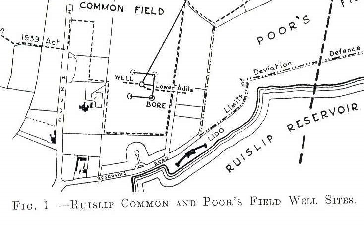
The position of the well was in the field behind the houses on the north side of Reservoir Road as shown on figure 1. Progress was slow owing to war-time difficulties of man-power shortage and poor quality materials, so that it was not until April 1942 that the 8 foot diameter well bottom was reached at a depth of 275 feet and the top 100 feet had been lined with steel tubes. It had gone through 37 feet of clay, 25 feet of Reading Beds and into 213 feet of the Upper Chalk. The trouble with the whole enterprise was that it failed to produce the hoped for yield of water. Prior to the deposit of the Bill, consulting geologists had stated that 2.5 m.g.d (million gallons per day) was not an over optimistic estimate, but apparently with no basic reasoning in support. An initial flow of 0.4 m.g.d looked encouraging, so an addit (tunnel) was driven north under Copse Wood and then north-east under Poor’s Field, (see figure 1) to tap more of the chalk, but the yield only increased to 0.8 m.g.d. This was eventually coaxed to 1.1 m.g.d after a total of some 300 feet of costly tunnelling. Figure 1 shows that to go under Poor’s Field meant going beyond the Limits of Deviation of the 1939 Act. In peace-time this would have necessitated going back to Parliament to get a new Private Bill passed, but under the Defence Regulations the Minister of Health simply issued an Order to legalise progress in June 1943. The Order was subsequently confirmed by Parliament retrospectively in 1945.
It was decided to sink a temporary 12 inch exploratory bore towards the northern end of Poor’s Field (see figure 1) and it was completed by August 1943. It went to a depth of 330 feet and the results were felt to be sufficiently encouraging to justify a proper well. However, Poor’s Field is common land, so a site for a 5 foot diameter well was arranged on land adjacent, in what was then the northern end of the Reservoir property (figure1). The concrete capped well surrounded by iron railings, and looking like the tomb of some forgotten warrior, can still be seen beside the Ruislip Nature Local Reserve. It was completed to a depth of 300 feet by August 1944. A yield addit was extended under Poor’s Field as shown. This eventually provided 2.25 m.g.d. With the 1.1 m.g.d from the first well it was decided to build a treatment works to handle 3.5 m.g.d on the site of the original boring. The operational buildings at the site of number 1 well appeared very temporary and I can remember the chugging of the pumps in the 1950s. It is so often difficult to recall when things actually cease. My best estimate is that water production stopped in the late 1950s/early 1960s. A letter dated 5th October 1977 to Mr S.W. Hester from Mr John Christie, Chief Engineer, Colne Valley Water Co. says: “It may be of interest to you to know that the combined reliable yields of the Ruislip Common and Poor’s Field wells fell far short of the hoped for 3.5 m.g.d. When we last used them some years ago the yield was about 1.5 m.g.d.”.
Footnote: -
What an interesting summary!
S.W. Hester was my father. He took a great interest in the problem of finding sufficient water in the area to supply the local needs. He was baffled by the decision to sink the well at the chosen site as the site was contra-indicated by the theory he had used to site several successful wells elsewhere. As I recall, the reason the site was chosen at all was simply that acquisition of the right to dig was easy!
My father sited the successful well at Jacket's Lane. I recall going down in the bucket and being very impressed with the inflow. My father was also involved in providing advice that led to the clearing out of the channel of the River Pinn after the flood of 1936 or 1937.
Brian Hester
[i] S.W. Hester Archive: personal possession.
[ii] Hal Wallhouse, Genesis of a Pumping Station, The Surveyor and Municipal and County Engineer, 10th May 1946.
[iii] S.W. Hester Archive: personal possession.
[iv] Uxbridge Gazette: 27 May 1992
[v] Ibid: 17. 6. 92
[vi] Ibid: 6.7.94
[vii] Ibid: 16.3.94